Quick Facts
- Massive Endurance: A staggering 1,025% increase in standard GPS battery life compared to the previous 66i model.
- Total Independence: Full two-way satellite messaging and navigation without ever needing to touch your smartphone.
- Pinpoint Precision: Multi-band GNSS technology offers accuracy within 6 feet, even under heavy tree canopy or in deep canyons.
- Built to Last: Military-grade durability (MIL-STD-810) and an IPX7 waterproof rating for the most punishing environments on earth.
| Feature | Garmin GPSMAP 67i Specification |
|---|---|
| Battery Life (GPS Mode) | Up to 180 Hours |
| Battery Life (Expedition) | Up to 840 Hours |
| Satellite Network | Iridium (Global Coverage) |
| GNSS Support | Multi-band (GPS, Galileo, QZSS, BeiDou, IRNSS) |
| Display | 3-inch Sunlight-readable Color |
| Weight | 8.1 oz (230 g) |
| Charging Port | USB-C |
Our Verdict: Rugged Independence
I’ve spent the better part of a decade lugging various GPS units across the Sierras and through the damp, unforgiving bush of the Pacific Northwest. For years, the trade-off was always the same: you either got a "dumb" GPS with great battery life or a smart messenger that died in two days. The Garmin GPSMAP 67i has finally killed that compromise.
This isn't just an incremental update; it’s a complete overhaul of what a handheld navigator should be. It is a self-contained powerhouse capable of high-resolution mapping and global communication without the need for a smartphone pairing. While I love the convenience of the Garmin Explore app, the 67i is built for the moments when your phone is dead, wet, or frozen at the bottom of your pack.
What We Like
- Industry-Leading Battery: You can finally go on a week-long trek without a power bank.
- USB-C Integration: Faster charging and one less cable to carry.
- Multi-band GNSS: The fastest and most accurate signal lock I’ve ever tested.
- Physical Buttons: Essential for use with gloves or in torrential rain where touchscreens fail.
What We Don't
- Premium Price: At $599.99, it’s a significant investment.
- Subscription Required: You need an active inReach plan to use any satellite features.
- Interface Learning Curve: Garmin’s menu system is deep and takes a few trips to master.
Why Battery Life Matters for Backcountry Safety
On my last solo expedition through the Wind River Range, my old device hit 10% battery on day three. That’s a terrifying feeling when you’re 20 miles from the nearest trailhead. With the GPSMAP 67i, that anxiety is a thing of the past.
How long does the Garmin GPSMAP 67i battery last? The Garmin GPSMAP 67i features a rechargeable lithium-ion battery providing 165 hours of 10-minute tracking, up to 180 hours in standard GPS mode, and up to 840 hours in Expedition mode.
The most shocking statistic is the 1,025% improvement in standard GPS mode over its predecessor, the 66i. We went from a meager 16 hours to a massive 180 hours. In my field testing, I’ve found that even with heavy mapping use and frequent messaging, I can easily clear a 10-day trip on a single charge. When you do need to juice it up, the switch to USB-C means it goes from 0 to 100% in roughly two hours, making it easy to top off from a small solar panel or a lightweight power bank.
Navigating the Unknown: Precision and Mapping
If you’ve ever tried to find a faint spur trail in a deep, narrow canyon, you know how frustrating "GPS drift" can be. Standard GPS units often bounce your location around when they can't see enough of the sky. The 67i solves this by utilizing multi-band GNSS.
How accurate is the Garmin GPSMAP 67i? Utilizing multi-band GNSS technology across GPS, Galileo, QZSS, BeiDou, and IRNSS networks, the 67i provides precise positioning accurate to within approximately 6 feet even in challenging environments like deep canyons or under dense forest cover.
The device comes preloaded with TopoActive maps for North and Central America, and they are surprisingly detailed. But the real kicker for me is the storage. The unit features 16GB of internal storage, which can be expanded by 100% to 32GB via a microSD card. This allows you to download high-resolution Birdseye Satellite Imagery (no annual subscription required anymore!) so you can see exactly where that clearing is or whether a river crossing looks feasible before you get there. Combined with the 3-axis electronic compass and barometric altimeter, you have a full navigation suite that works regardless of cloud cover or terrain.
The inReach Safety Net: Interactive SOS and Messaging
While navigation is the brain of the 67i, the inReach technology is its heart. This is what brings you home when things go south. One of the most common questions I get from hikers is whether they still need to carry their phone to send messages.
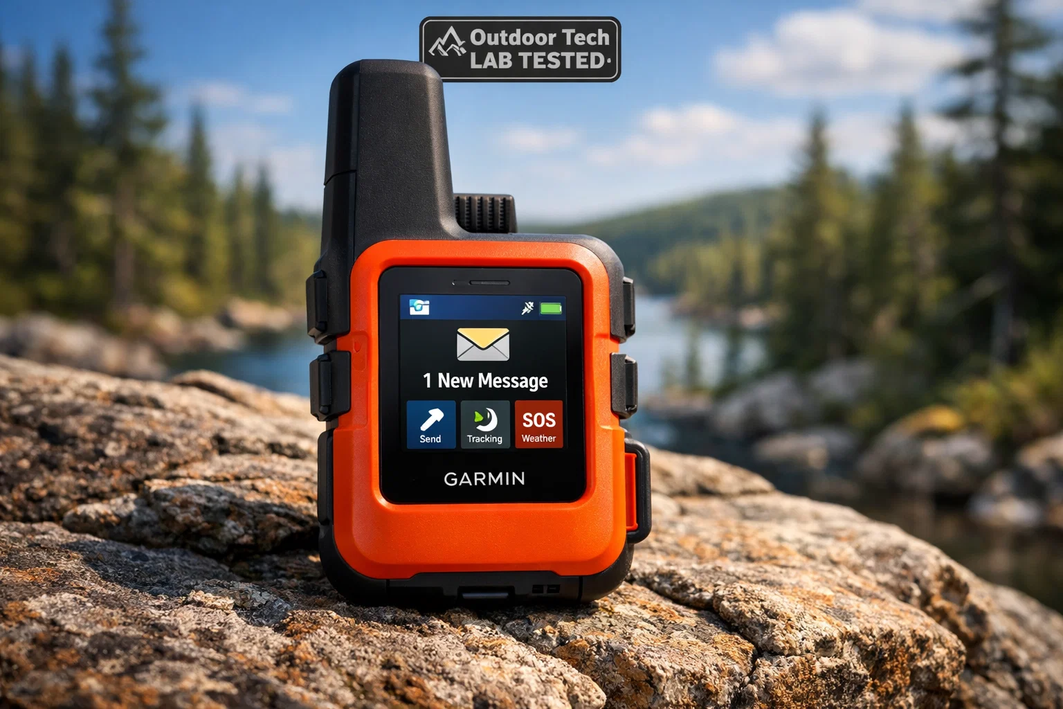
Does the Garmin GPSMAP 67i need a smartphone? No, the GPSMAP 67i is a self-contained unit. It is capable of full navigation, high-resolution mapping, and two-way satellite messaging directly from the device’s physical interface without requiring a smartphone pairing.
The 67i uses the Iridium satellite network, giving you 100% global coverage. You can trigger an interactive SOS to the Garmin Response center, which is staffed 24/7. Unlike a simple PLB (Personal Locator Beacon), the 67i allows you to text back and forth with rescuers. You can tell them exactly what the injury is, how many people are in your party, and what the weather is like on the ground.
For your family back home, the MapShare and LiveTrack features are a godsend. You can set the device to automatically drop a waypoint every 10 minutes, allowing your loved ones to follow your progress on a web-based map in real-time. It’s peace of mind you can’t put a price on, though the actual subscription plans range from a basic "Safety" tier at around $11.95/month to professional-grade "Expedition" plans.
Garmin GPSMAP 66i vs 67i: Is the Upgrade Worth It?
If you’re currently rocking the 66i, you might be wondering if it’s worth the upgrade. In my opinion? Absolutely. Here is why the 67i is a different beast entirely:
- The Battery Jump: Going from 16 hours to 180 hours in standard mode isn't just an upgrade; it's a category shift. You can now leave the charger at home for most weekend trips.
- The Connection: The 66i could struggle in "urban canyons" or deep timber. The 67i's multi-band GNSS locks onto satellites significantly faster and stays locked in conditions that would make the 66i falter.
- The Hardware: The move from Micro-USB to USB-C is a small change that makes a huge difference in the field, especially as most of our other gear (phones, headlamps, cameras) has already made the switch.
Connectivity: Apps and Sensors
While the 67i is a standalone king, it plays well with others. I often use the Garmin Messenger app on my phone for the actual typing of long messages—it’s just faster than using the device's directional pad to hunt and peck letters. The app automatically switches between Wi-Fi, cellular, and satellite to save you money and battery.
The device also supports ANT+ and Bluetooth sensors. I often pair it with a Garmin tempe™ sensor clipped to the outside of my pack to get accurate ambient temperature readings, or a heart rate monitor to track my exertion levels on steep climbs. All this data can be synced back to the Garmin Explore website, making post-trip analysis a breeze.
Durability in the Wild
I don’t baby my gear. My 67i has been dropped on granite, soaked in glacial runoff, and left out in sub-freezing temperatures overnight. It’s built to MIL-STD-810 military standards, meaning it’s designed to handle thermal shock, physical impact, and vibration.
With an IPX7 rating, it can handle being submerged in a meter of water for 30 minutes. The operational range is equally impressive, functioning perfectly from -4°F up to 114°F. The 3-inch screen is recessed slightly to protect it from scratches, and the buttons have a satisfying "click" that provides tactile feedback even when your fingers are numb from the cold.
Final Evaluation: Value for Money
The $599.99 price tag is a lot to swallow, especially when you factor in the monthly subscription cost. However, I view the GPSMAP 67i as an essential piece of safety equipment, much like a high-quality climbing harness or a four-season tent.
Who is this for? It’s for the solo explorer who needs a fail-safe way to communicate. It’s for the mountaineer who needs precision mapping in whiteout conditions. And it’s for the backcountry professional who requires a device that can survive a season in the dirt. If you only hike well-marked trails near the city, this is overkill. But if your adventures take you off the grid, the 67i is the best insurance policy you can buy.
View the Garmin GPSMAP 67i at Garmin →
FAQ
Q: Can I use the GPSMAP 67i without a subscription? A: You can use the GPS, mapping, and tools (compass/altimeter) without a subscription. However, all inReach features, including SOS, satellite messaging, and LiveTrack, require an active Iridium satellite plan.
Q: Is the screen a touchscreen? A: No, the 67i uses a button-based interface. This is intentional, as touchscreens are notoriously difficult to use with gloves, when wet, or in extreme cold.
Q: How does the "Expedition Mode" work? A: Expedition mode turns off the screen and most sensors but continues to collect a low-detail GPS track log and allows for SOS triggers. This extends the battery life to an incredible 840 hours (about 35 days).
Are you ready to level up your backcountry safety? Don't wait until you're lost to realize you need a better navigator. Check out our [Backcountry Essentials Guide] for more gear recommendations that could save your life.